 Hoosiers by the Numbers
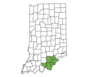
EGR 10 includes Clark, Crawford, Floyd, Harrison, Scott, and Washington counties.
Economic Growth Region 10 Analysis

EGR 10 is situated between the Ohio River and the rolling hills of scenic Southern Indiana.
Several landmarks punctuate this region’s natural beauty, including the Falls of the Ohio in Jeffersonville, Squire Boone Caverns and O’Bannon Woods State Park near Corydon, and the Hoosier National Forest.
The region has a rich history, and because of its proximity to the Ohio River, was one of the first parts of the state to be settled by Europeans. In June 1816, delegates met under the shade of a large elm tree in Corydon to draft the first state constitution, paving the way for Indiana statehood in December 1816. Corydon remained the state capital until 1825, when it was moved to Indianapolis.
The region’s industry strengths include manufacturing, health care, and accommodation and food services, and some of its top employers include Caesars Southern Indiana, Baptist Health Floyd, and NYX New Albany. The region’s education institutions include Indiana University Southeast in New Albany and Ivy Tech in Sellersburg.
Recent Analysis

Labor Market
Review
December 2025 
Industry Sector Snapshot
Second Quarter 2025
Occupational Employment Statistics
2024 Annual
Real-Time
Job Demand
Fourth Quarter 2025 
Unemployment Claimant Profile
Fourth Quarter 2025
Access archived publications via the Publication Lookup Tool.
Sign up for EGR 10 updates to receive new regional reports via email
Subscribe »Quick Stats
Click on any quick stat to view details and a comparison table.

Contact your regional analyst
Need help? Knowledgable regional analysts are available to offer assistance.Jillian Gregory
Email: [email protected]
Phone: (812) 270-9476
Articles by this analyst
- A look into Indiana's winery production industry (Sept-Oct 2024)
Top 10 Occupation Groups by Growth
(2023-2033 long-term projections)
- Healthcare support occupations
- Architecture and engineering occupations
- Computer and mathematical occupations
- Life, physical, and social science occupations
- Healthcare practitioners and technical occupations
- Community and social services occupations
- Business and financial operations occupations
- Personal care and service occupations
- Installation, maintenance, and repair occupations
- Education, training, and library occupations
Source: U.S. Bureau of Labor Statistics and Indiana Department of Workforce Development
Dive into the long-term occupation projections with the Employment Outlook Projections Tool.
Top 10 Industry Sectors
(Based on 2024 annual average employment)
- Manufacturing
- Health Care and Social Services
- Retail Trade
- Accommodation and Food Services
- Transportation & Warehousing
- Educational Services
- Construction
- Admin, Support, Waste Management
- Professional, Scientific, Technical
- Wholesale Trade
Source: Quarterly Census of Employment and Wages
Access multiple data sets on the Industry topic page.
Major Employers (Based on number of employees)
Explore even more employers by location, size class or industry with the Business Lookup Tool.
EGR 10
- Amazon Fulfillment Center
- Caesars Southern Indiana
- Baptist Health Floyd
- NYX New Albany
- Norton Clark Hospital
- Indiana University Southeast
- PharmaCord, LLC
- Shoe Sensation Inc.
- Samtec Inc.
- Hitachi Cable America Inc.
About the data
Note: The list of regional employers on this page was updated July 2025 to include local insights.
![]() This database contains listings of nearly 12 million U.S. employers. Employer information is provided by Data Axle®, Omaha, NE, (866)-DATAXLE. Copyright © 2026. All Rights Reserved.
This database contains listings of nearly 12 million U.S. employers. Employer information is provided by Data Axle®, Omaha, NE, (866)-DATAXLE. Copyright © 2026. All Rights Reserved.
Major Educational Institutions
Name |
Type |
City |
|---|---|---|
| Indiana University Southeast | Four-year | New Albany |
| Ivy Tech - Sellersburg | Two-year | Sellersburg |
| Ottawa University - Jeffersonville | Independent | Jeffersonville |
Source: Indiana Commission for Higher Education
Use INTraining to search for
training and education programs
Largest Cities and Towns in Economic Growth Region 10
| Name | Population in 2024 | Percent of region | County |
|---|---|---|---|
| Jeffersonville | 52,912 | 16.9% | Clark |
| New Albany | 37,652 | 12.0% | Floyd |
| Clarksville | 22,041 | 7.0% | Clark |
| Sellersburg | 10,057 | 3.2% | Clark |
| Charlestown | 8,559 | 2.7% | Clark |
| Scottsburg | 7,413 | 2.4% | Scott |
| Salem | 6,463 | 2.1% | Washington |
| Austin | 4,156 | 1.3% | Scott |
| Georgetown | 3,837 | 1.2% | Floyd |
| Corydon | 3,153 | 1.0% | Harrison |
Source: U.S. Census Bureau annual population estimates

Helpful Tools and Resources
EGR 10 IN Depth Regional Profile
At-a-glance details about the region's population, labor force, housing and more.County Highlights
Get a snapshot of critical population and workforce statistics for each county in the region.INDemand Jobs
Find job postings and training for the jobs that are both high wage and high demand.Regional Labor Mix
Discover the regional mix of occupations and/or industries to gain insight into strengths or identify gaps.Regionizer
Build a region to view demographics, commuting patterns, industry clusters and occupation clusters, including the ability to include counties that border Indiana.
Labor Force Projections
These are the official labor force projections to 2050 released in September 2018 by the Indiana Business Research Center.
Commuting
The commuting data page provides easy access to multiple commuting data sets and visualizations.
Regional Links
View A to Z Guide for a list of external links statewide.